Beach Stone Lakes/Point Pleasant Flood Plan
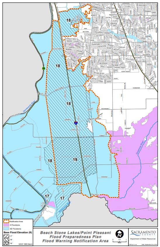
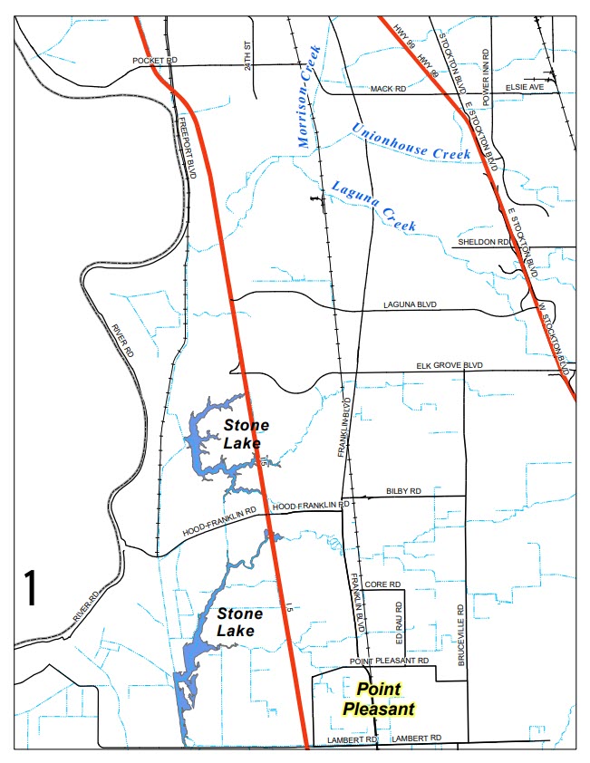
Location Map: Point Pleasant lies within the Beach Stone Lakes (BSL) area. The BSL area is bounded by the Southern Pacific Railroad (SPRR) on the west, Lambert Road on the south, the Western Pacific Railroad (WPRR) on the east, and Morrison Creek on the north. Point Pleasant is in the southeastern corner of that area.
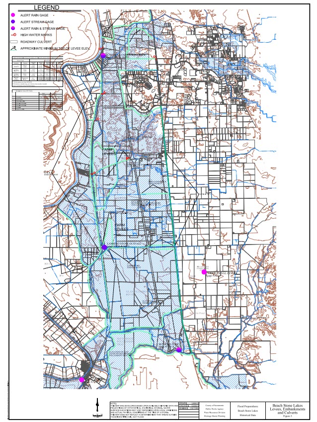
Levees and Embankments: Shows the location and elevations of key structures affecting flood depths in Point Pleasant levees and embankments.
Location Map: Point Pleasant lies within the Beach Stone Lakes (BSL) area. The BSL area is bounded by the Southern Pacific Railroad (SPRR) on the west, Lambert Road on the south, the Western Pacific Railroad (WPRR) on the east, and Morrison Creek on the north. Point Pleasant is in the southeastern corner of that area.
Evacuation
The Benson's Ferry forecast should give residents up to five days to consider their course of action before flooding occurs in the BSL/Point Pleasant area. Residents can monitor the rain and stream gauge information on this website, as well as track the progress of the storm on local news. The shorter the time frame of the forecast, the more reliable it is.
If residents do not leave the area prior to flooding, the best way to leave the area during a flood is to take Point Pleasant Road to Franklin Boulevard, then drive north on Franklin Boulevard and then east on Elk Grove Boulevard to Highway 99.
For those who choose not to evacuate, it is recommended that a local flood response plan be developed by the residents. There are areas of relatively high ground that may serve as a temporary shelter, such as the Point Pleasant United Methodist Church at 3329 Point Pleasant Road. Helpful information on flood preparedness planning is available on Four Steps to Flood Safety.
Sources of Flooding
The BSL area floods from different sources:
- Morrison Creek Stream Group (180 square miles watershed) from the north
- Local runoff (50 square miles) entering between Morrison Creek and Lambert Road
- Cosumnes and Mokelumne Rivers (1,800 square miles) which back up along the east side of the WPRR and flow through the bridge openings and breaches in the UPRR embankment.
Due to restricted capacity through the Delta, Cosumnes and Mokelumne River flows backup Snodgrass Slough and flow north over Lambert Road. The Lambert Road bridge has flap gates which prevent flow from passing north. However, when the water on the south side of Lambert Road exceeds 13.3 feet elevation (NAVD88 datum) water spills north into the BSL.
Flood Warning
Flood events in the BSL area are volume-related as opposed to peak flow. It takes several days or more of rainfall to produce flood conditions in BSL. Because of this, and the length of time it takes rain in the upper reaches of the watershed to reach BSL (for perspective it takes about one day for flows at Michigan Bar to reach Benson's Ferry), there is some time to assess conditions before flooding in Point Pleasant occurs. Residents can monitor rain and stream gauges on the internet for both real-time and forecasted conditions.
Flood elevations at Benson's Ferry reached 20.6 feet in 1986 and 20.9 feet in 1997 (vertical datum NGVD 1988). The relationship of Benson's Ferry elevations to Point Pleasant flooding isn't direct (flooding in Point Pleasant was actually worse in 1986) because it depends on the storm type and levee failures. However, the Benson's Ferry gauge is the best tool to warn residents of pending flood status because it has five days of forecasted flood elevations. Forecasting is a tool to make us aware of what may occur, becoming more accurate as peak stages approach. Yet, the steps needed to reduce flood damage and protect lives may require preplanning and early action.
The following table shows various flood elevations at Benson's Ferry, how it relates to the area, and the potential impacts and actions to be taken.
| Forecasted Benson's Ferry Elevation [ft*] | Impacts | Recommended Actions |
|---|---|---|
| 17.0 | Flood Stage. Some local farm roads are closed. Low lying areas along the river are flooded. Twin Cities Road begins to flood. | Residents should begin monitoring website. Consider actions to protect equipment and livestock. |
| 18.0 | Field flooding likely. Lambert Road east of Franklin Blvd. begins to flood. Cosumnes and Mokelumne River overflows may enter Point Pleasant from the east. | Consider flood fighting measures, such as sandbags, around structures. |
| 19.0 | Lambert Road may be impassable. | Consider relocating to high ground. |
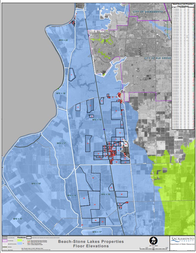
| 20.6 | High water in 1986 | Point Pleasant flooded to elevation 14.0 NGVD29 (16.3 feet NAVD88) |
| 21.0 | High water in 1997 | Point Pleasant flooded to elevation 11.8 NGVD29 (14.1 feet NAVD88) |
The Michigan Bar stream gauge can also serve as a warning tool since it has a five-day forecast, and it takes an additional day to reach Benson's Ferry. However the relationship of Michigan Bar elevations to Point Pleasant flood elevations is less reliable than Bensons Ferry so was not used in public notification. Following is a table showing various historic peak flood elevations at Michigan Bar Road.
| Observed Stage at Michigan Bar | Date of Observed High Stage | Comments |
|---|---|---|
| 13.18 | 1/11/2017 | Successive storms caused a large volume of water to backup Snodgrass Slough. |
| 14.76 | 2/17/1986 | Levee and railroad embankment failures exacerbated flood levels in Point Pleasant. |
| 15.19 | 2/10/2017 | Successive storms plus the prior month’s event extended the period that stages remained high in Snodgrass Slough and the Mokelumne River. |
| 18.54 | 1/2/1997 | Levee failures along the Cosumnes River in the Wilton area lessened flooding experienced in Point Pleasant. |
Real Time Conditions
To view ALERT stream level data click the following links
Forecasted Stream Levels
- Mokelumne River - Benson's Ferry (THTC1)
- Cosumnes River - McConnell (MCNC1)
- Cosumnes River - Michigan Bar (MHBC1)
- Help with reading these charts
Public Notification
Letters will be sent to residents in the notification area shown in the Flood Warning Notification Area Map once a year. This will remind residents of the flood risks, this website, and the County’s emergency alert notification system. Residents who wish to be called when flooding appears possible are asked to sign-up for Sacramento-Alert notifications at www.sacoes.org.