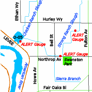
American River Monitor Stage and Flood Risk
The D-05 drainage facility discharges storm water to the American River through a combination of gravity outflow and pumps. The rate of gravity outflow for this facility is influenced by the stage in the American River in the vicinity of the D-05 drainage basin.
When the American River is below monitor stage, the D-05 drainage facility provides roughly 25-year protection for the Lower Chicken and Strong Ranch Sloughs area.
When the American River is above monitor stage, the capacity of the gravity outlet starts to diminish, reducing the level of flood protection. As the river climbs higher, the amount of protection lowers to as little as 5-year protection. (2” of rain in 12 hours is about a 5-year event.)
Although river stage plays an important part in defining your flood risk, property owners are encouraged to pay close attention to local weather reports at all times, since flooding can occur on Lower Chicken Ranch Slough and Lower Strong Ranch Slough even when the American River is below monitor stage.
Monitoring Stream and Weather Conditions
When water is high in the American River (monitor stage or above), an intense local rainfall event can cause Strong Ranch Slough to rise very rapidly, giving very little warning time of potential flooding. In addition, if the Strong Ranch Slough ALERT gauges hit monitor stage and are rising and
radar shows more rain coming, then the likelihood of flooding is high. Therefore, property owners near Strong Ranch Slough are encouraged to pay close attention to weather forecasts and the ALERT stream gauges in their area, and take precautions, especially when American River stages are high.
Real time conditions
To view ALERT stream level data click the following links
D-05 pump station and detention basin operation
Strong Ranch Slough channel drains from El Camino Avenue at Walnut Avenue southwesterly to the County D-05 detention basin and pump station at Hurley Way and Ethan Way. The basin and pump station are located up against the American River levee. The detention basin collects the runoff and either allows it to drain through the levee through a large culvert opening in the levee, or over the levee with one small low flow pump and 6 larger high flow pumps.
When the river is low the culvert through the levee allows runoff from Strong Ranch Slough to pass through the levee and drain directly into the river by gravity. When river flows are high enough that the American River could back up through the culvert and begin to fill the basin, a large slide gate is automatically closed on the culvert to prevent this from occurring. However, closing the gate also prevents Strong Ranch Slough runoff from draining through the culvert, and thus requires that the pumps be operated to allow the basin and slough to drain.

Additional studies
Watershed Alternatives Analysis: An analysis prepared by David Ford Consulting Engineers to evaluate potential solutions for improving flood protection in the Lower Chicken and Strong Ranch Sloughs area.
Woodside Interior Floodwalls Concept Drawings: This document outlines conceptual requirements for floodwalls that could be constructed to protect individual residential buildings within the Woodside Condominiums area. Any projects of this type would have to be pursued at the discretion of the specific residents involved.
